Winter in Colorado is on track to be snowier, but not colder, meteorologists say
North and central mountain resorts might not share in the rest of the state’s above-average snowfall, estimates show

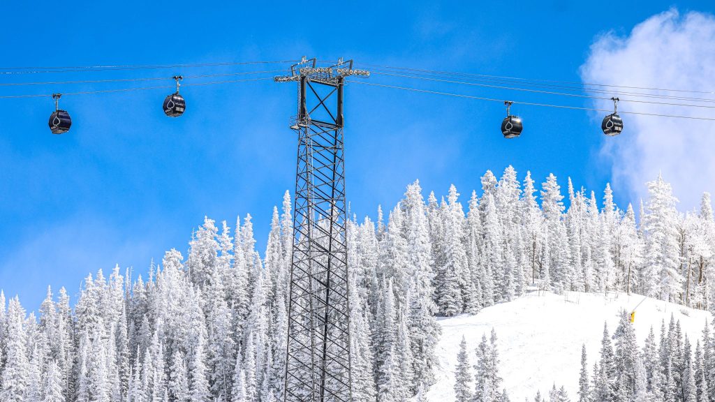
Austin Colbert/The Aspen Times
New winter forecasts favor above-average snowfall for southern and eastern Colorado, promising some much-needed relief after months of drought and hotter-than-average temperatures. For Colorado’s northern and central mountains, however, predictions of snowfall are less clear.
When El Nino conditions officially arrived in June, the U.S. National Oceanic and Atmospheric Administration noted that it could intensify into a “strong” or “super” El Nino by the end of the year — potentially breaking historical records going back to the 1950s.
El Nino conditions — characterized by above-average sea surface temperatures across the central to eastern equatorial Pacific Ocean — have strengthened since June, which OpenSnow Meteorologist Alan Smith said has increased confidence that a very strong, or “super” El Nino, will prevail through the upcoming winter.
“If this ends up being a record-setting event and just blowing the strength of all other El Ninos out the door, that could lead to some surprises or some elements that we just can’t really foresee,” Smith said. “It’s hard to say because we don’t really have anything to compare that to to know what that might look like.”
While most of the state is on track to recover some of the lost snowfall from the lackluster 2025-26 season — largely thanks to the strengthening El Nino — OpenSnow’s 2026-27 winter forecast shows equal chances of above- or below-average snowfall for the Western Slope mountains.
Forecasts indicate that events from strong El Ninos could result in above-average snowfall across the San Juan Mountains, as well as in the eastern mountains near or east of the Continental Divide. This includes areas like Telluride, Silverton, Wolf Creek, Eldora, Winter Park, and Loveland, according to the Wednesday OpenSnow report.
Ski resorts located in Colorado’s northern and central mountains — such as Keystone, Breckenridge, Copper, Vail, Aspen, Crested Butte, and Steamboat — don’t have a clear signal in either direction.
Stronger El Nino winters are typically accompanied by an active subtropical jet stream across the Southern U.S., Smith said. Consequently, mountains in the southern part of the state are better-positioned for these storms.
“Northwest Colorado is kind of in a weird spot,” Smith said. “It’s just less clear of a signal, because sometimes when storms track across Southern Colorado they end up largely missing northwest Colorado, but then other times you can get favourable storm tracks that track far enough north to hit the whole state.”
The months of November-December and March-April are currently favored for the heaviest snowfall, while January and February will likely see lighter totals. This is typical for El Nino winters, Smith said, which bring a more active storm track early and late in the season, broken up by a lull in the middle.
“That’s not to say that this winter’s going to follow exactly like that. Every winter is going to be unique in its own way,” he said.
Snowier — but warmer — winter ahead
More snow doesn’t necessarily mean colder weather.
OpenSnow meteorologists are favoring above-average temperatures across a large portion of North America, including the northern half of Colorado. The southern half of Colorado is showing equal chances of above- or below-normal temperatures, thanks to an active southern storm track that is favored during strong El Nino winters.
“Historically, cold air originating in the Arctic has a hard time spilling southward into southern Canada and the U.S. during strong El Niño years,” Smith wrote in the report. “That’s not to say it won’t happen, it’s just expected to happen less frequently than usual.”
Repeat of last winter? Not exactly
Smith clarified that a forecast of above-normal temperatures doesn’t necessarily equal “well-above normal” temperatures like the ones seen during the 2025-26 winter season. In other words, northwest Colorado will likely still be colder and snowier than last year.
“Looking at some of the ski resort records and mountain snowpack records, it seems that in western Colorado there’s not a huge anomaly in either direction,” he said. “I would say that the odds of having an extremely low snow year like last winter are low. I think at the very least, it’s likely that this year will be improved over last year, but it’s hard to say whether or not it’ll be a truly big winner.”
Although seasonal weather predictions are hardly a guarantee, having two back-to-back years with record-low snow is highly unlikely, Smith said. The presence of El Nino is also expected to mix up the weather pattern enough that dry periods won’t be as dominant as they were during the 2025-26 winter season.
The same is true for the forecast above-average temperatures.
“Last winter was exceptionally warm — the warmest on record for a large portion of the West — and it’s unlikely it will be that warm again this winter even if this above-average outlook verifies,” Smith wrote in the report.
An early glimpse of autumn
Following weeks of hot and dry weather in the High Country, Smith said the approaching wave of monsoonal moisture in Colorado could signal the start of a transition into more autumnal weather.
“We saw a little bit of [monsoonal moisture] during the second half of July, though it didn’t really come with the cooler temperatures,” he said. “What we’re seeing this week is a stronger push of monsoonal moisture that looks to be more sustained into the western U.S., and we’re also seeing a trend toward cooler temperatures, which is something we haven’t had much of in a long time.”
Above-average moisture and rainfall are favored heading into September, which could stem from an active monsoon season lingering late into the summer. Alternatively, the pattern could potentially point to some early fall systems, Smith added.
“That doesn’t necessarily mean we’re going to be seeing below-average fall temperatures from the get-go, but I do think things are looking a bit cooler for the later part of the summer compared to what we’ve had recently,” he said. “Once we head into October and November with El Nino, we do see that signal toward a higher likelihood of early-season winter storms and above-average snowfall early in the season, so it could be … an earlier start to the snow season this year. That’s what El Nino tends to favour.”
As it pertains specifically to skiers and winter sports enthusiasts, Smith said he recommends looking at short- or medium-term forecasts when booking trips for snow recreation, as snow totals can vary heavily even during a strong El Nino season.
“Seasonal forecasts can tell you how the dice may be loaded one way or another, but there’s always going to be inter-seasonal variations,” Smith said. “If you’re trying to plan a ski trip, for instance, a winter forecast isn’t necessarily going to help you out with that because it’s still going to vary a lot week-to-week and you’re still better off looking at short-term weather forecasts for actually planning ski days on the slopes.”




Support Local Journalism
Support Local Journalism
The Sky-Hi News strives to deliver powerful stories that spark emotion and focus on the place we live.
Over the past year, contributions from readers like you helped to fund some of our most important reporting, including coverage of the East Troublesome Fire.
If you value local journalism, consider making a contribution to our newsroom in support of the work we do.