Monthly wolf activity maps
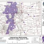
The state releases monthly maps showing wolf activity, tracks depredations and compensates ranchers who file a claim following a depredation.
-
July’s Colorado wolf activity map shows the movement of the collared animals between June 24 and July 22.
Colorado Parks and Wildlife/Courtesy Photo
-
The June 2025 wolf activity map.
Colorado Parks and Wildlife/Courtesy Photo
-
A map showing which Colorado watersheds collared gray wolves were between April 22 and May 27, 2025. This is the furthest south and west wolves have been tracked since reintroduction began in December 2023.
Colorado Parks and Wildlife/Courtesy Photo
-
-
The April wolf activity map shows one wolf traveling solo through the southern portion of the state, as well as substantial movement from others across the state.
Colorado Parks and Wildlife/Courtesy Photo
-
The March map shows Colorado’s collared gray wolves have moved a bit more compared to the previous 30 day period.
Colorado Parks and Wildlife/Courtesy Photo
-
Each month, Colorado Parks and Wildlife releases maps showing which watersheds collared wolves traveled in. The latest map shows where there was wolf activity from the 28 collared animals between Jan. 21 and Feb. 25
Colorado Parks and Wildlife/Courtesy Photo
-
Watersheds are highlighted purple in areas where Colorado’s collared wolves were detected in November. The wolves traveled mostly in Northwest Colorado according to the map released on Dec. 23, 2024.
Colorado Parks and Wildlife/Courtesy illustration
-
Collared wolf activity between Oct. 22-Nov. 26, 2024.
Colorado Parks and Wildlife/Courtesy image
-
Colorado Parks and Wildlife released a new wolf activity map on Sunday, Nov. 4 as a collared wolf was tracked south of I-70 for the first time since reintroduction.
Colorado Parks and Wildlife/Courtesy photo
-
Colorado Parks and Wildlife released the October wolf map.
Courtesy image
-
The August collared wolf activity map shows that a wolf entered Rocky Mountain National Park for the first time.
Colorado Parks and Wildlife/Courtesy image
-
The Colorado Parks and Wildlife July wolf activity map shows less movement compared to June.
Colorado Parks and Wildlife/Courtesy photo
-
June’s Colorado wolf activity map shows the collared animals moving deeper into Summit and Eagle counties.
Colorado Parks and Wildlife/Courtesy Image
-
The latest wolf map released by Colorado Parks and Wildlife shows activity from April 23 to May 21.
Colorado Parks and Wildlife/Courtesy image
-
Colorado Parks and Wildlife released the latest collared gray wolf activity map on Apr. 24, showing new wolf activity in watersheds east of the Continental Divide and onto the Front Range.
Colorado Parks and Wildlife/Courtesy image
-
This Colorado Parks and Wildlife map, released March 27, shows watersheds in which at least one wolf has traveled over the last 30 days.
Colorado Parks and Wildlife/Courtesy photo
-
The Colorado Parks and Wildlife map shows where wolves traveled in Colorado between Jan. 23 and Feb. 27.
Colorado Parks and Wildlife/Courtesy photo
-
Colorado Parks and Wildlife has created a Collared Gray Wolf Activity Map that will help inform the public on where gray wolves have been in the past month. The map will be updated with new information on a monthly basis, produced on the fourth Wednesday of every month, and will reflect data for the prior month, give or take several days.
Colorado Parks and Wildlife/Courtesy photo
Colorado Wolf Release 12-18-23 from Colorado Parks & Wildlife on Vimeo.